What if Brazil merged with Peru

1. GENERAL NUMBERS
For mere convenience, here we consider that the merger does not include Loreto, and that advanced calculations showed that Brazil before the merger, called Brasil Atlântico, had a 4.32% loss in area (from 8,510,417,771 km² to 8,142,767.723 km², in all states) and former Peru without Loreto had 5.22% (from 1,285,216 km² to 1,218,127.724 km² over country, 368,851 km² to 349,596.978 km² in Loreto).
With the merger with Peru, Brazil gains a wide exit to the Pacific, an excellent part of the Andes, absolute depressions, the entire main legacy of the Incas, interesting notes of volcanism and a fantastic boost in flora and fauna.
Brazil, refered here as Brazil Expanded, would be the 3th largest country in the world (excluding Loreto area, 368,851.95 km²), with 9,011,298.46 km² (WIKI), after China (9,326,410), U.S.A. (9,147,593 km²), Canada (9,093,507 km²) and Russia. In population, has 242.82 M inhabitants, making the country the 5th largest in the world (WIKI), 17 M more than Pakistan and 29 M less than Indonesia. After unification, Brazil had the fifth large land area.
2. STATES
In Brazil United at our simulation, Madre de Díos and Ucayali would be incorporated by Acre state, Loreto excluded, and remainign 21 subjects would be new Brazilian states such as:
Tumbes ‣ 120,091 km², including actual Tumbes, Piura, Lambayeque, Cajamarca and Amazonas, slightly smaller than Amapá; 4.66 M pop., more populous than Espírito Santo.Huayhuash ‣ 219,031 km², the trunk of atual Peru, including actual La Libertad, Ancash, Huanuco, Pasco, Lima, Junin, San Martín and Huancavélica, slightly smaller than Paraná; 21.75 M pop., making it the second most populous state in the country, but only about 0.5 M more populous than Minas Gerais.Atacama ‣ 90,188.85 km², including actual Arequipa, Moquegua and Tacna, equivalent to Santa Catarina; 1.57 M pop., equivalent to Tocantins.Copacabana ‣ 213,275.85 km², including actual Ica, Ayacucho, Apurimac, Cuzco and Puno, equivalent to Roraima; 4.12 M pop., equivalent to Espírito Santo.
Acre expanded, including former Madre de Dios and Ucayali, would have 323,702 km², slightly smaller than Mato Grosso do Sul, and 1,375 M inhabitants. The map of Brazil, in this new scenario, look like the figure below.

3. REGIONS
With the 30 states plus the Distrito Federal, Brazil would have a different distribution of regions, with the following measures:
São Paulo was incorporated into the SOUTH region.Rio de Janeiro, Minas Gerais, Espírito Santo and Bahia compose the EAST region.The NORTHEAST was reduced to the 7 most internal states.Maranhão, Pará, Amapá and Tocantins compose NORTH of Brazil.Rondônia joined to the former Center-West compose the called simply CENTER.Roraima, Amazonas and Acre compose the NORTHWEST region.Tumbes, Huayhuash, Copacabana and Atacama compose WEST region.

4. STATIAN MAP

5. BORDERS
Brazil Expanded, compared with actual Brazil, would lose 1,565 km of the Acre/Peru border, would gain 168 km with Chile, an additional 1,075 km with Bolivia, 791 km with Ecuador and 1,441 km with Loreto, leaving it with 16,601 km, remaining in the 3th position worldwide (WIKI), about 3,500 km less than Russia, 2th place. Brazil wuold have 12 neighboring countries, 3th in the world; would continue in the 7th position in number of border lines. The border with Chile wuold be the Brazilian smallest national border (WIKI/Borders of Brazil), and the border with Bolivia, with 4,468 km, wuold be 5th longest in the world (Statista).
 |
| BRAZIL NEW BORDERS AND TRIPOINT IN BRAZIL, ECUADOR AND LORETO |
With the annexation of Peru, Brazil gains direct access to the Pacific Ocean, but not only that. It acquires within its territory a vast expanse of a very high mountain range (the Andes), a zone among the driest in the world (the Atacama), manifestations of tectonism (volcanoes, geysers), absolute depressions, salt flats, deep underwater trenches, Lake Titicaca, and an incredibly diverse biodiversity at the level of angiosperms and metazoans.


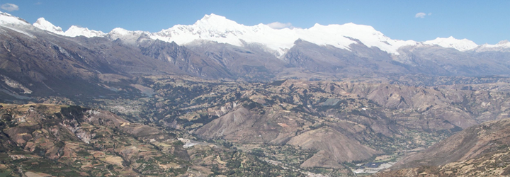


SOME NATURAL LANDSCAPES IN W BRAZIL
6. PACIFIC COAST
Brazilian coastline wuold have 7,491 km of Atlantic coast and 2,414 km of Pacific coast, thus placing it at 9,904 km (WIKI/World Factbook) and in 12th position, behind the United Kingdom and ahead of Mexico. Therefore, we wuold have two coasts, something shared with only 22 other countries (WIKI), and we are part, with Canada, U.S.A., Mexico, Guatemala, Honduras, Nicaragua, Costa Rica, Panama and Colombia, of the group of Atlantic/Pacific countries. Brazilian Pacific EZZ has 906,454 km² (Wikipedia). Larger Pacific coasts includes Alaska (10,690 km), Mexico (7,338 km), Chile (6,435 kms) and U.S.A. except Alaska (3,289 km).
 |
| BRAZILIAN PACIFIC EEZ |
7. EXTREMES
The western end of the Brazil wuold be Punta Pariñas (SEE), also the western end of the South American continent, making Brazil have the entire length of the American continent and the only one in the world with such, next to Australia.

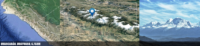
8. MOUNTAINS
At altitude Brazil wuold have a good part of the territory at high altitude. The highest mountain wuold be Huascarán, the 4th highest mountain in the Andes, Western and Southern Hemisphere (WIKI), at 6,768m (578m higher than Denali in the U.S.A. and 1,158m higher than Orizaba in Mexico). This mountain is the highest in the tropics, its summit is the 2
th
farthest point from the center of the Earth and the point on the Earth's surface with the
least gravity
(
WIKI
).
9. HIGHLANDS
The actual Peru was the 13th country in average altitude at 1,555m, being the 2th largest in the New World and the 4th largest outside Asia (WIKI); with actual Brazil and its average 320 m, the average of the unified country dropes to 482 m - and the 70th position among independent countries.
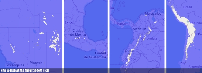
10. ALTIPLANO
The Central Andean altiplano, with a considerable portion in the south of western states, is the 2th largest in the world after Tibet (WIKI).

11. HIGH CITIES
The highest permanent city in the world wuold be Brazilian: La Rinconada, Copacabana (WIKI), at 5,052m altitude, in a ranking of highest cities wuold dominated by Bolivia, Brazil, China and India.


12. ABSOLUTE DEPRESSIONS
Brazil wuold have absolute depressions. There are 67 negative basins in the world, and the Saline Depression (sometimes Salina Grande) in Tumbes, at -34m (or only 22m, by CPG, 1991), is the lowest in the southern tropics (WIKI; No a La Mina); counties with deepest depressions are Argentina (3 lower basins, record -105m), U.S.A. (10 lower basins, record -86m), Jordan/Israel (7 lower basins, record -430m), Kazakhsthan (1 lower basin, -138m), China (1 lower basin, -154m) and 6 other northern African countries. Map below created with Contour Map Creator.

13. WATERFALLS
Brazil wuold have the 3th tallest waterfall worldwide: Tres Hermanas Falls, with a height of 914 m. It is located inside Otishi National Park, near the northern fork of the Cutivireni River, in the Brazilian state oh Huyahuash (Wikipedia).
14. DEEP OCEAN
On the ocean coast, Brazil wuold have its deepest oceanic region in Pacific side, in the Brazil-Chile rift (Polina Lemenkova, Polish Cartographic Review, 2019), which sweeps the entire Brazilian Pacific coast, and reaches more than 8,000m in depth in Chile; in Brazil Expanded, this crevice does not reach -7,000m, and the lowest point, also not determined, varies between -6,300 and -6,400m. Results make by this blog, in manual search, found a point at -6,365m, off the coast of Huyahuash, at exact location 10º22'25.60'' S and 79º58'46.08'' W.

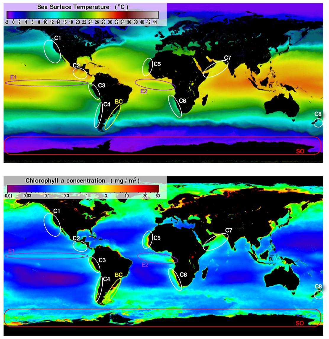
15. HUMBOLDTII UPWELLING
Coastal upwelling is a major oceanic process driven by prominent currents, of which those within Eastern Boundary Upwelling Systems (EBUS) are most important globally. EBUS include the California (CCS), Humboldt (HCS), Canary (CnCS), and Benguela (BCS) current systems (SEE). It'ss a highly productive ecosystem, the most productive eastern boundary current system, accounting for roughly 18-20% of the total worldwide marine fish catch (SEE).
|
| SOME DATA ABOUT THE FOUR LARGE UPWELLING SYSTEMS WORLDWIDE |
16. WATER SUPLY
Brazilian freshwater supplement wuold be 10,146 km³, well over double that of Russia and triple that of the U.S.A. or Canada, the next on the list (WIKI).
17. LAKES
Lake Titicaca, shared between expectable Copacabana state and Bolivia, is the highest navigable lake in the world, non freezing, the 13th largest freshwater lake in the world by volume with 893 km³ of water and the 3th in the Southern Hemisphere and Latin America (WIKI); on the surface, it is very discreet, being 19th with 8,362 km², if some saline lakes (WIKI) are included in the list. At maximum depth it is not among the 36 largest in the world, but at average depth it is 34th, with 107 m, being at this point the superlative of Latin America. In all these aspects, it wuold be the largest lake in Brazil; for several details, we have World Lake Database (SEE), Lake Titicaca permanent Observatory (SEE), Facts on Titicaca Lake (Victor M. Ponce), FEOW (SEE), and Lakenet (SEE).

18. ENDORRHEIC BASIN
Titicaca includes a remarkable endorrheic basin with 9 sub-basins, 7 of them in Brazilian Expanded territory; for details of this basins, see Zola et al (Hydrology and Earth System Sciences Discussions, 2018).
19. SALT FLATS
Salt flats in Brazil wuold be very rare and small; the most remarkable of them wuold be Salar Laguna Blanca, a salt flat located on the international border between Brazil and Chile, within the so-called Andean Altiplano; it occupies an area of 19.5 km², 2/3 of the salt flat are in Brazilian territory and 1/3 in the Chilean Region of Arica and Parinacota; with a SW-NE orientation and a irregular, the salt flat rises to a height of 4,253 m above sea level (Wikipedia).
 |
| SALAR LAGUNA BLANCA |
20. CLIMATE
In terms of climate (see Climate of Peru), the Amazon rainforest is identical in its entirety, but the Andean regions and the coastal desert provides a vast area of microthermal climate throughout the year, with the expectable Brazilian altiplano being the coldest region in the country, where not infrequently it reaches -10 or -12ºC, and the average during the day in spring oscillates between 5 and 10ºC, with occasional snowfall between April and September. The coldest event record wuold be -25.2°C in Mazo Cruz (Copacabana) on June 30, 1966, and the highest (hottest event), in Brazil, wuold be 44.8°C in Nova Maringá, Mato Grosso do Sul, on November 4, 2020. Brazilian hottest event possibly is the lowest documented in South America except for Uruguay and Venezuela, and the coldest, the 3th coldest after Argentina and Chile.
The wettest point in Brazil wuold be the San Gaban (13°27'39.14" S, 70°24'35.95" W), also in Copacabana, with declared annual 6,249.2 mm, but with the possibility of reaching up to 8,000mm annual. The driest point, in declared terms, wuold be the station of La Haciendita in Islay region of Arequipa (16°59'54.99" S, -71°36'2.98" W), with a average precipitacion 0,8mm (SENAMHI).
 |
| HEAVY SNOW IN ATACAMA, 2018 (andina.pe) |
21. VEGETATION
In terms of vegetation, forest wuold cover 5.301 million km² (WIKI/FAO) of Brazilian territory, 2th in the world but well behind Russia; we wuold have 73٪ of the Amazon. Brazil wuold have vegetation associated with the Andean mosaic and associated with the coastal desert mosaic, the most notable being the Andean transition forests, the puna (WIKI), the lomas (WIKI) and the true paramos, in the extreme north of the Andean region (MOBOT).
22. HOTSPOTS
Brazil wuold have the large portion of Tropical Andes Biodiversity Hotspot; for more details for tis region, see Pronaturalez (BOOK, 2021) and Maria Gonda (BOOK, 2020).
23. EARTHQUAKES
The biggest earthquake in Brazil after unification was 6.6ºR in Mato Grosso in 1955 (Superinteressante); after unification, this is only be the 85th! An iterative map with the earthquakes in the western portion of Brazil Expanded can be in Volcano Discovery (SEE), which points at 8.4ºR the most violent, Arequipa Earthquake (SEE), state of Atacama, in June 06, 2001. This earthquake wuold be the 16th largest national earthquake ever recorded (disregarding the Arica earthquake in 1868) and, of these, the 3th largest after the 2000s (WIKI).
 |
| GENERAL STATUS OF EARTHQUAKE SEISMOLOGY IN WEST BRAZIL; ORIGINAL IMAGE IN EARTHJAY. CLICK TO ENLARGE |
24. VOLCANOES
Brazil wuold have 10 volcanoes that erupted in the last 7 thousand years, 7 of which in the last 2 thousand years, and two (Ubinas and Sabancaya) in the last 10 years (Global Volcanism Program).
 |
| MAP OF SW BRAZIL AND THE ACTIVE AND POTENTIALLY ACTIVES VOLCANOES. CLICK TO ENLARGE. |
 |
| UBINAS VOLCANO IN COPACABANA STATE |
25. GEOTERMICS
As for geothermalism, geyser fields, associated with tectonism, are absent in Brazil after unification, but occur in 70 points in the world, 13 in South America, 1 in Bolivia, 4 in Chile, 2 in Argentina and 5 in new states of Brazil (Scott Bryan, 2018) which, in addition to the Shanay Timpishka River, add up to 6 hotspots in the country.
However, a more accurate analysis from geotermy in western states shows more than 500 points among six systems. Hot springs located in the northern and central western Brazilian states have a meteoric origin, where the high temperature manifestations are product of the geothermal gradients; in southern systems geothermal manifestations are related to active volcanism and in some cases are of mixed origin, the water from precipitations infiltrates and it is heated by a heat source on depth (Vargas & Cruz, Proceedings World Geothermal Congress, 2010).
 |
| GEOTERMIC AREAS IN WESTERN STATES |
26. BIOLOGICAL NOTES
With the annexation of Peru, Brazil gains a great diversity associated with the Andes and the Pacific Ocean. This includes a high number of species of Mollusca and Malacostraca, the rare lineage of Monoplacophora, diverse lineages of Anura and birds from mountain habitats, significant increases in Brassicaceae, Amaranthaceae, and Caryophyllaceae, the new orders Fagales, Huertales, and Desfontainiales of Angiosperms, and a remarkable diversity of cushions, to name a few examples. For details on these data, see Brazil SD: Metazoa Adds and Angiosperms from Brazil SD.
Brazil now wuold have two poles of power: the Atlantic, formed by the Rio-São Paulo axis, and the Pacific, formed by Huayhuash state. Few countries in the world have two poles of power, such as USA (New York and California, longitudinal) and China (Beijing and Honk Kong, latitudinal).
Lima has about 8.89 M inhabitants as a city itself (WIKI,), ranking 28th among the largest in the world and 3th in the Americas behind Mexico City (-320K) and São Paulo (-3.3M); in the metropolitan area they are 9.56M, 24th in the world and 9th in the Americas behind Mexico City, São Paulo, New York, Los Angeles, Buenos Aires, Rio de Janeiro, Bogotá and Chicago; in a conurbated area it is only the 42th, with 9.56M inhabitants and also in the 9th position, behind the same cities in the previous item. As a municipality, it´s be the 2th largest in the country.


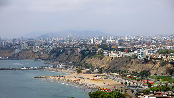
LIMA, CAPITAL FROM HUAYHUASH
26. DEMOGRAPHIC
Brazil wuold have an remarkable treasure: most of the Inca heritage (SEE), one of the most advanced pre-Columbian civilizations, one of the five clades of civilization (WIKI) within a very select group that includes China, but not the U.S.A. The lingua franca of country wuold be Portuguese and Spanish, although officially only Portuguese, with 242 M native speakers, still being in 6th position in this ranking (WIKI). With 29.83 M Spanish speakers, concentrated on the Pacific coast, Brazil wuold have the 7th largest Hispanic population on the planet (WIKI). Assuming that less than 10 languages established in Brazil are spoken in western new states, between 300 and 310 languages are established in the country (more than 97٪ indigenous), going to the 5th or 6th greatest diversity in the world (WIKI).
In addition to the average urban Brazilian, the average rural Brazilian, the northeastern Brazilian, the southern Brazilian and the Amazonian Brazilian, Andean Brazilian is a new group, a people with a strong indigenous influence (as well as the Amazon) adapted to the mountains, including there tens of millions of people. Quechua and Aymara wuold be the two more indigenous languages in the country, along with Guarani from the center south. Brazil has 6.7 M indigenous people (WIKI), the second largest in the Americas - 87٪ of this contingent in the 4 pacific states, mainly in Huayhuash.
Other elements that are part of the national culture includes some icons of the country: new animals (llama, condor, bear, penguins), the mountain landscapes, the Nazca lines (SEE), the rainbow mountain Vinicunca (SEE), the cities of Macchu Picchu and Cuzco, and the Huacachina oasis (SEE) - all of these in Copacabana.
27. ECONOMY
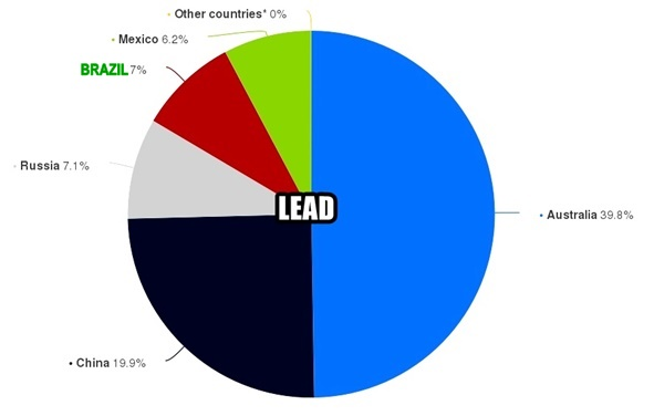
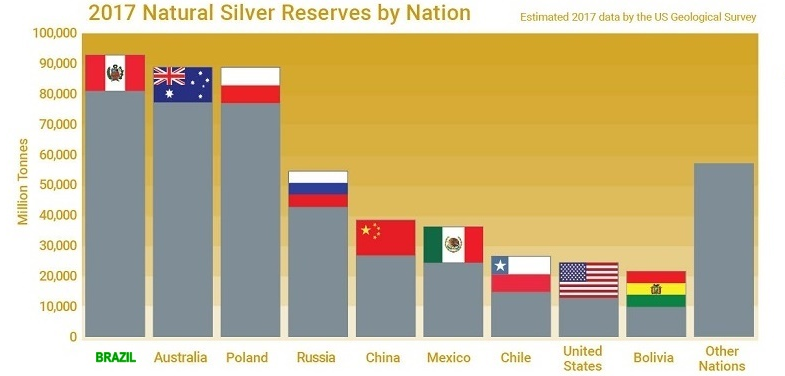
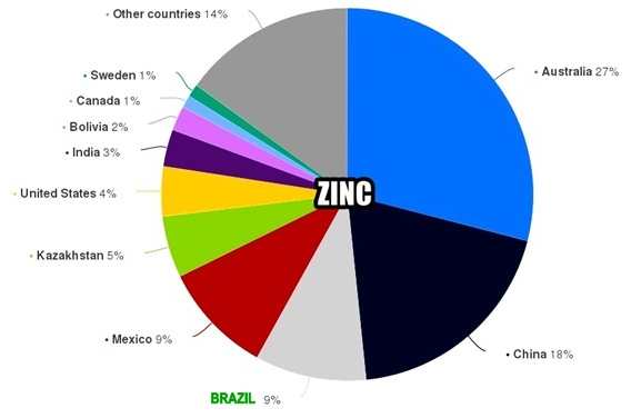
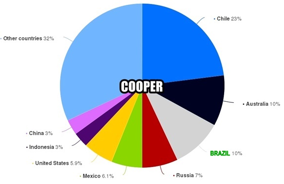
In economics, according to the World Bank (WIKI), Brazil wuold have a nominal GDP of US$ 1.646 T, going from 12th to 9th position. In mining, with data together, we wuold be the 2th largest producer of copper, zinc and silver, 3th of lead, 4th of gold, tin and molybdenum and 5th of boron (WIKI/Links do USGC), by reserves from western states. In fishing (WIKI), in fish capture Brazil wuold be at 6th place, with 4.516 M t/year. Brazil wuold be the king of commodities.
 |
 |
 |
 |
Brazil wuold be now the 9th largest potato producer (WIKI), in addition to notable production of blueberries, quinoas and avocados in western states.
 |
| BRAZILIAN CROPS CENTERED IN THE NEW STATES AFTER UNIFICATION |
With Brazil united with Peru, the list of missing elements would be modified.
1.2 HYDROTERMAL VENTS▸ince the first discovery of vents in 1977, some 700 hydrothermal vent species previously unknown to science, together with 600 species at cold seeps, have now been described (German et al., Plos One, 2011). Worldwide this places occur in over Pacific Ocean, scarce points in Indian Ocean, Red Sea, Mediterrânean, Arctic, and in Meso-Atlantic Ocean; the closest occurrences to Brazil are c. 2,500 km away, in the middle of the Atlantic at the same latitude of Pernanbuco, Paraíba and Rio Grande do Norte; for details about this, see German et al. (Earth and Planetary Sciences Letters, 2008).
 |
| xyz1 WORLD DISTRIBUTION OF HYDROTHERMAL VENTS |
2.1 FJORDS ▸ a fjord or fiord is a long, narrow inlet with steep sides or cliffs, created by a glacier. Fjords exist on the coasts of Alaska, Antarctica, British Columbia, Chile, Denmark, Germany, Greenland, the Faroe Islands, Iceland, Ireland, Kamchatka, the Kerguelen Islands, Labrador, Newfoundland, New Zealand, Norway, Novaya Zemlya, Nunavut, Quebec, the Patagonia region of Argentina and Chile, Russia, South Georgia Island, Tasmania, United Kingdom, and Washington state. Norway's coastline is estimated to be 29,000 km (18,000 mi) long with its nearly 1,200 fjords, but only 2,500 km (1,600 mi) long excluding the fjords (Wikipedia). Saco do Mamanguá, a ria in southern Rio de Janeiro state in Brazil (Ecobrasil), is sometimes (and erroneously) reported a single tropical fjorde wordwide (Guia Viaje Melhor).
 |
| FJORDS WORLDWIDE |
2.2 ANCHIALINE CAVES▸anchihaline (or anchialine) habitats are water bodies in hollows along the sea coasts where the influence of the sea may be felt and which are inhabited by some obligatory subterranean species. Or, more accurately, they belong to “a tidally influenced subterranean estuary located within crevicular and cavernous karst and volcanic terrains that extends inland to the limit of seawater penetration.” In New World anchialine caves occur in Caribbean, Mexico, Central America, Venezuela, Bermudas, Florida, Galapagos Is. and Hawaii; for diversity of life in anchialine caves, see Perez-Moreno et al. (International Journal of Speleology, 2016); for Bermudas, with 78 spp., 66 of them Crustaceans, see Iliffe & Gutiérrez (Diversity, 2021).
Globally, crustaceans represent the most diversified group of anchialine fauna, with at least 500 species described, belonging to 4 classes, 16 orders, and 57 families. Several taxonomic groups of crustaceans, including the class Remipedia, the peraccharides of the orders Mictacea and Bochusacea, and the copepods of the order Platycopioida have been designated from specimens collected in this medium and are found exclusively in groundwater (Romero, Anartia, 2019).

In Mexico, anchialine caves are only known in the Yucatan Peninsula, with over 2,241 cenotes recorded; a half of this sysmtems have records for only one to three species, five caves with more than ten records, while only three an chialine systems possess representatives of more than two phyla. Despite an apparently low diversity in this region, Calderón-Gutiérrez et al. (2017) performed an exhaustive diversity survey at El Aerolito cenote, which extends for 18 km, and reaches a maximum depth of 27 m. They reported that El Aerolito cave system holds 100 species (53 as new records, and 47 previously reported), grouped within 10 phyla (Porifera, Cnidaria, Platyhelminthes, Nemertea, Sipuncula, Annelida, Arthropoda, Mollusca, Echinodermata, and Chordata). These authors pointed out that El Aerolito is the richest and foremost biodiverse anchialine system of the world, and it could be a result of the energy input to the system by mangroves in the main entrance, and the direct connection with the sea, together with the chemosynthesis processes that occur there (Romero, Anartia, 2019).
ANCHIALINE CAVES WORLDWIDE (NEIBER ET AL., 2011)

In Venezuela, so far, only two endemic anchialine species, Cyathura univam (Isopoda: Anthuridea) (Botosaneanu 1983) and Metaniphargus venezuelanus (Amphipoda: Hadziidae), have been reported, and they were described from specimens collected in a cave not yet officially record- ed by professional speleologists in Falcon state, specifically in the Mallorquines karst (Botosaneanu’s Cave, Morrocoy peninsula). These two species are the only representatives of their respective groups in South America and they were the result of the 1982 Amsterdam Expedition to the Venezuelan Islands and other localities on the mainland (Romero, Anartia, 2019).
3.1 SNOW WINTERS/BLIZZARDS ▸ as a tropical country, Brazil does not have severe winters, with regular temperatures that are always positive, with negative national records almost never lasting more than 24 hours; blizzards are also very rare. In addition to tropicality, the fact that the Southern Hemisphere is more covered by oceans makes the existence of such winters, and the landscapes and phenomena associated with them, difficult.
 |
| WINTER COVERAGE THROUGHOUT THE YEAR, HIGHLIGHTING WHERE THE RIGOROUS WINTER ADVANCES IN THE NORTHERN HEMISPHERE |
3.2 HURRICANES ▸ because the South Atlantic basin is generally not a favorable environment for their development, Brazil has only rarely experienced tropical cyclones. The country's coastal population centers are considered less burdened with the need to prepare for cyclones, as are cities at similar latitudes in the United States and Asia; Hurricane Catarina was the first and only South Atlantic tropical cyclone to have reached hurricane strength, and impacted Santa Catarina as a Category 2 storm in 2004. It reached sustained wind speeds of 155 km/h (100 mph) and a pressure of 972 millibars (Wikipedia).
 |
| HISTORIC SERIES OF HURRICANES, AND IMAGE OF HURRICANE CATARINA, UNIQUE IN THE HISTORY OF BRAZIL |
4.1 MIDNIGHT SUN▸the midnight sun is a natural phenomenon that occurs in the summer months in places north of the Arctic Circle or south of the Antarctic Circle, when the Sun remains visible at the local midnight. When the midnight sun is seen in the Arctic, the Sun appears to move from left to right, but in Antarctica the equivalent apparent motion is from right to left. This occurs at latitudes from 65°44' to 90° north or south, and does not stop exactly at the Arctic Circle or the Antarctic Circle, due to refraction; the opposite phenomenon, polar night, occurs in winter, when the Sun stays below the horizon throughout the day (Wikipedia).
ARTIC COUNTRIES, WHERE THE MIDNIGHT SUN OCCURS

4.2 AURORAS▸also commonly known as the polar lights,[c] is a natural light display in Earth's sky, predominantly seen in high-latitude regions (around the Arctic and Antarctic). Auroras display dynamic patterns of brilliant lights that appear as curtains, rays, spirals, or dynamic flickers covering the entire sky; aurora australis is visible from high southern latitudes in Antarctica, Chile, Argentina, South Africa, New Zealand, and Australia. The aurora borealis is visible from being close to the center of the Arctic Circle such as Alaska, Canada, Iceland, Greenland, Norway, Sweden, Finland and Russia. On rare occasions the aurora borealis can be seen further south, for example in Estonia, Latvia, Lithuania, Scotland, Ireland, Denmark, and the northern part of the contiguous United States (Wikipedia).

5.1 PENINSULAS ▸a peninsula is a landform that extends from a mainland and is surrounded by water on most, but not all of its borders; a peninsula is also sometimes defined as a piece of land bordered by water on three of its sides; peninsulas exist on all continents; the size of a peninsula can range from tiny to very large. The largest peninsula in the world is the Arabian Peninsula (Wikipedia).
 |
| LARGEST AND MOST CLASSICAL PENINSULAS WORLDWIDE |
5.2 GULFS AND SEAS ▸here is no clear definition of what is bay, gulf or sea; in this way, there are bays larger than seas, lakes called sea, gulfs more open than coasts that do not take any special name, assigned to classical, media or historical names. On the map below we highlight all the major maritime bodies in these categories, with the notable highlight that there are almost none of these in South America.
 |
| SOME CLASSIC GULFS, BAYS AND SEAS WORLDWIDE (CLICK TO ENLARGE) |
6.1 RELATED TO ANIMAL MIGRATIONS ▸monarch butterfly (Danaus plexippus, Nymphalidae) has the longest migration trajectory of any insect; every November, the forest located between the Mexican states of Michoacan and Estado de Mexico is covered in fluttering orange, black, and white insects; as part of their migration cycle, monarch butterflies fly around 2,800 miles from Canada and the United States to spend the coldest months of the year in warmer lands. Brazil no has none massive migration of insects (Travel Leisure).
 |
| DETAILS FOR MONARCH BUTTERFLIES MIGRATION |